Why River Crossings Draw Roads Together
River crossings draw roads together where a bridge, ford or ferry links banks. Read the approaches, terrain and nearby places to see what routes connect.
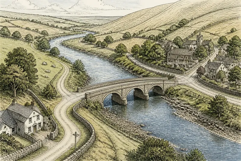
River crossings draw roads together where a bridge, ford or ferry offers a practical way between banks. On a county map, roads may converge near the water because the crossing connects places that the river otherwise separates.
To understand that pattern, look beyond the crossing mark. Trace the approaches on both banks, note the nearby settlements and follow the roads onward. These details help distinguish a direct route between two places from a crossing that links several local roads.
Rivers and road barriers
A river can carry boats while obstructing travel on land. Steep banks, marshy ground, a deep channel or fast water can make it difficult to cross, even where the river looks narrow on a small-scale map.
Roads therefore tend to meet the river where a usable passage exists. A bridge spans the channel; a ford allows passage through shallow water when conditions permit; and a ferry connects landing places on opposite banks. The route pattern depends partly on which kind of crossing is shown.
A road may bend towards a bridge rather than continue straight to the river. On the far bank, another road may approach at an angle or turn towards a nearby settlement. The routes need not line up neatly to form a useful connection.
Routes around a crossing
A crossing can connect roads that serve different purposes. Lanes from farms or villages may feed into one approach, while a road on the opposite bank continues towards a town or junction. The bridge is then a link within a wider network, not simply the end of a road.
Imagine a county map showing a bridge beside a village. A lane from farms on the west bank bends towards the bridge; on the east bank, a road joins the village street and continues inland. Tracing both routes suggests that the bridge links the farms and village to places beyond the river. The map alone does not show how busy those roads are.
Start at the crossing and trace each road outwards. This makes it easier to see whether a route serves nearby places, continues to a larger road, or does both.
Map clues and decisions
Check the map legend before interpreting a crossing symbol: conventions vary between maps. Then follow the road line across the channel. A line that reaches the bank without a clear crossing mark may end there, follow the river or connect through a feature represented another way.
Contours and land shading can help you assess the approaches. Closely spaced contours suggest steeper ground, while gentler slopes may offer easier access. These signs describe the landscape generally; they do not establish the exact condition of a bridge, ford or riverbed.
- Crossing symbol: If the legend identifies a bridge, ford or ferry, treat that as the mapped passage; if it shows no passage, check for another symbol or map layer before assuming the road crosses.
- Road line: If the route continues clearly onto the opposite bank, follow it to its next junction; if it stops at the water, treat it as an apparent end until another mapped link is confirmed.
- Approach roads: If lanes converge on one crossing, trace each to its settlement or junction; if they lead to different passages, compare those routes separately.
- River shape: If the channel narrows or bends near the passage, note that as a possible clue to the crossing’s location; if it remains broad, rely on the mapped crossing and approaches rather than guessing from shape alone.
- Relief: If contours show gentler ground on both approaches, note the access as relatively less steep; if they show steep slopes, avoid describing the approach as easy.
- Route continuation: If roads lead onward to several places, describe the crossing as part of a broader connection; if they serve only nearby places, describe it as a local link.
Each clue supports a different decision: the legend identifies the mapped passage, the roads show what it connects, and the relief helps explain the approaches.
Different approaches
Roads on opposite banks do not have to meet the crossing in a straight line. One approach may turn towards a town, while the other skirts steep ground or joins a lane from a nearby farm. The map can show how these routes connect without revealing the precise reason for their alignment.
Several crossings may appear close together. Compare the roads leading to each one and the settlements they serve rather than assuming that every nearby route uses the same passage. A road running alongside the river may also meet another road near the water without crossing it; look for a marked passage and a continuing route before calling it a bank-to-bank link.
River crossing map questions?
How can you tell whether a road crosses the river?
Check the legend for a bridge, ford or ferry symbol, then trace the road line across the channel. If the line stops at the bank, do not assume it continues over the water.
Why might a crossing sit at a bend?
A bend may bring routes on both banks within reach of a shared passage, or the approaches may suit the local terrain. The map suggests these relationships but cannot, by itself, establish why the crossing was chosen.
Do roads meeting at a bridge always serve a town?
No. They may connect farms, villages, junctions or roads along the river. Trace each route outward to identify the places it reaches.
What if several crossings appear close together?
Compare each crossing’s type, approaches and connected places. If their routes lead in different directions, describe them as separate links rather than one shared route.
Reading the wider link
A crossing draws roads together when it provides a usable route between banks, but the wider map shows the connection’s reach. A bridge may link several lanes, while a ferry or ford may serve a more specific set of routes. Nearby roads can also connect the crossing to places that never touch the river.
When reading river crossing roads on a county map, begin at the passage and work outwards on both banks. Check the crossing type, the shape of the approaches and the places reached beyond them. Comparing another crossing on the same river can clarify whether each serves local destinations or links a broader set of routes.
If you are using the map to plan an actual journey, treat it as a guide to the mapped network rather than a confirmation that a crossing is currently open or suitable. Check current local information before relying on a ford, ferry or bridge.