Ridge Road or Valley Road: What Each Route Reveals
Ridge road or valley road: learn to identify a route’s landform and understand how slopes, water and nearby places shape its course.
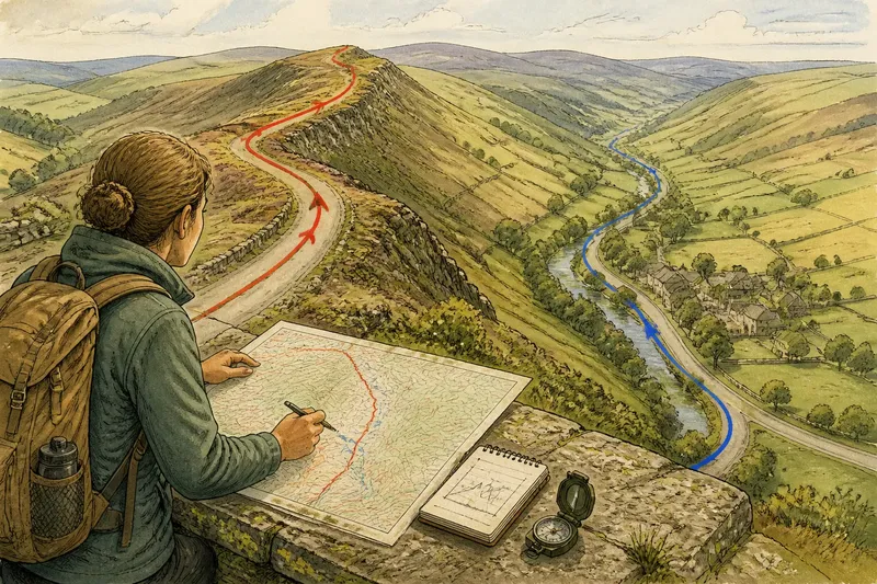
A ridge road follows high ground between drainage basins; a valley road follows a lower corridor shaped by slopes and water. To tell them apart, trace the route’s relationship to the surrounding land rather than relying on a long view, a nearby stream or a cluster of buildings alone. The distinction explains what the road connects and where its gradients may change.
Ridge road clues
A ridge is an elongated strip of higher ground, with land falling away on either side. A road may follow its crest, or a shoulder just below it, where the ground is less uneven or exposed. It can pass through a saddle, the lower notch between neighbouring high points, without ceasing to be part of the ridge route.
On a topographic map, trace the road against the shape of the land. Contour lines form closed loops around some summits and bend into valleys; a road that stays on the high spine between those descending lines may follow a ridge. The strongest clue is not that the road is high at one point, but that slopes fall away on both sides over a stretch of its course.
From a safe place to pause, the ground itself can clarify the map: look for opposing slopes and, where visible, streams that drain in different directions. A single viewpoint is not decisive; a shoulder or rounded hill can hide the crest.
Valley road clues
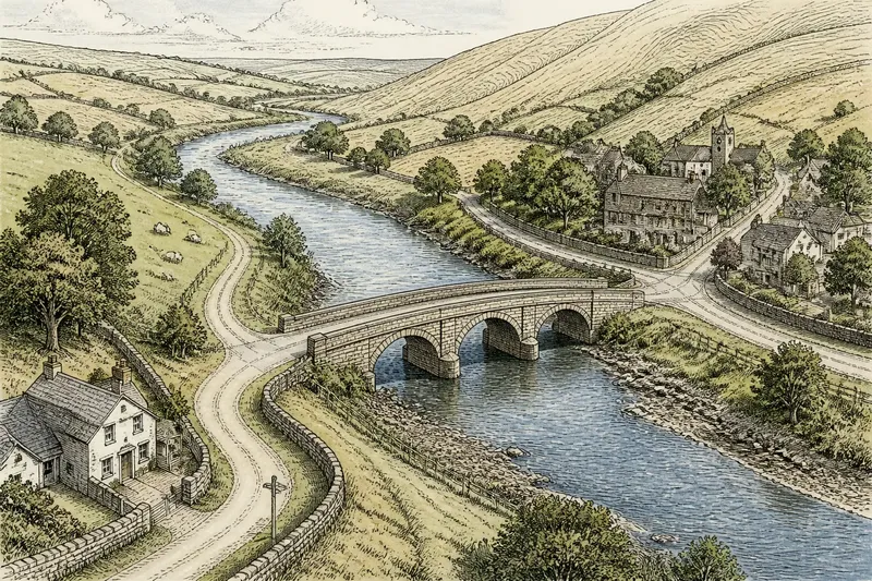
A valley road runs along lower ground between rising slopes. It may follow a river or stream, but it can also use a dry hollow or a terrace above the water. Roads often keep slightly above the lowest ground to avoid wet areas, steep banks or a confined gorge.
On a map, contour lines bend towards higher ground where a valley narrows upstream. If the road runs lengthwise through that lower corridor, rather than crossing from one slope to the other, it probably follows the valley. Check whether side lanes descend from farms or hamlets and whether the valley widens near a settlement; those details can explain the route’s purpose without making the settlement pattern a substitute for reading the landform.
A riverside road is not automatically a valley-floor road. It might sit on a raised bank, while a road farther away may still follow the valley’s broader shape.
Route shape and place
Ridge and valley roads often serve different kinds of connection. A ridge route can link high-ground farms or pass between neighbouring valleys without repeatedly descending to their floors. A valley route may connect places along a stream corridor, with side roads branching towards slopes and upland settlements.
Those patterns do not establish why a particular road or village began where it did. A settlement may occupy a sheltered terrace, a crossing point or the mouth of a side valley. Treat the road, landform and nearby places as related clues, not as proof that one caused the others.
Say you are comparing two routes to a village: one follows a high spine, then dips through a saddle; the other runs beside a stream before climbing to the village’s terrace. Trace both on the map, noting where each crosses closely spaced contours and where it follows broader, gentler ground. The ridge route avoids the valley floor but still has a saddle; the valley route stays low for longer but climbs at the end. Your answer is therefore a trade-off, not a blanket claim that one route is easier.
Gradients and ground
Contour spacing helps locate changes in slope. Closely packed lines indicate steeper ground; wider spacing indicates gentler ground. Follow the contours along the whole route, since a road can alternate between level stretches and short climbs. The map legend matters too: contour intervals and symbols differ between maps.
Valley floors can be relatively level, but the approaches into or out of a valley may be steep. Ridge roads can avoid deep descents while still climbing over a crest or dipping through a saddle. Neither landform name alone tells you which route is easiest.
Water and surface conditions add another layer. High ground often drains towards lower slopes, while valley floors collect water and material carried downhill. Yet rock, drainage works, weather and land management can change what the ground is like locally. A road may use a terrace or raised bank rather than the wettest part of a valley.
Compare routes on maps
For a useful comparison, choose a map with contour lines and a readable legend, then follow each route from start to finish. Record the landform clues and make a decision from their combination:
- Trace the route’s position: If it stays along an elongated high spine with slopes on both sides, treat it as a likely ridge route; if it follows lower ground between slopes, treat it as a likely valley route. If neither pattern continues, describe the route as mixed.
- Follow the contour bends: If the lines show the road tracking a high divide, count that as a ridge clue; if they bend towards higher ground on both sides of a lengthwise corridor, count that as a valley clue. If the pattern is unclear, check a larger-scale map rather than guessing.
- Check the watercourse: If a stream runs beside the route through a lower corridor, regard it as supporting valley evidence; if watercourses fall away in opposing directions, regard that as supporting ridge evidence. If water is absent or hidden, rely on the contours instead.
- Inspect contour spacing: If tight lines meet the route, expect a steeper section and compare alternatives there; if lines are more widely spaced, expect gentler ground at that point. If spacing changes along the journey, assess each section separately.
- Mark saddles and crossings: If the road dips between high points, identify a saddle and check whether it continues along the ridge or descends into a valley. If the route crosses the contour pattern repeatedly, classify it as crossing slopes rather than following either landform throughout.
- Place settlements in context: If lanes and buildings cluster along a lower corridor, note that the road may serve valley places; if farms or lanes sit along high ground, note a possible ridge connection. If the road’s position disagrees with the settlement pattern, describe both rather than letting one overrule the other.
These checks prevent one conspicuous feature from deciding the answer. A river, viewpoint or village can be useful, but the route’s continuing position relative to the slopes is more revealing.
Choosing a route?
Does a ridge road always follow the crest?
No. It may run along a shoulder below the crest, or dip through a saddle between higher points. Check whether high ground remains on both sides of the route over the section you are describing.
Is a valley road always beside a river?
No. A valley road may follow a dry hollow or a terrace set above a stream. Look for the lower corridor and the slopes around it, not just water at the roadside.
Which route has gentler gradients?
Neither label settles that question. Compare contour spacing along the entire route, including its approaches, and note where the lines tighten or spread apart.
Can one road follow both landforms?
Yes. A road may track a ridge, descend into a valley and climb onto another ridge. Describe each section by its position in the land rather than assigning one label to the whole journey.
Reading the route clearly
For a ridge road or valley road, combine the route’s position, the direction of the slopes and the contour pattern; use streams and nearby places as supporting clues. That method also makes mixed routes easier to describe, since it shows where a road follows a divide, where it enters a drainage corridor and where it crosses between them.
If you are planning to travel, use current local route information as well as the map. A map can show landform and likely gradients, but it cannot tell you the present condition of a road or path; check appropriate local guidance before setting out.