Green Map Shading Is Not Always Forest
Green map shading can mean woodland, grassland or designated open space. Learn to check the legend and describe a county landscape accurately.
Green map shading does not always mean forest: on a county map it may mark woodland, a park, rough ground or fields. To identify green map shading accurately, check the legend and the map’s purpose before naming the landscape.
Map purpose matters
A map’s colours are symbols, not universal labels. The legend, sometimes called the key, explains how that particular map uses them. A topographic map may distinguish woodland from heath, marsh or open land; a planning map may use green for designated open space. An online map may combine several kinds of vegetation under one shade.
Check the title, publisher and date as well as the map type. A county walking map, an aerial photograph and a land-use plan select and group information differently. The same patch can therefore have different colours or boundaries on different maps without the landscape itself changing.
Keep the map’s scale in mind, too. A county overview may simplify details that appear on a more local map, so a single broad category is not necessarily a precise description of what grows there.
Legend labels and land cover
Look for the exact wording beside the green symbol. A legend might separate “woodland” from “parkland”, or use a broad label such as “vegetation”. If the category is broad, colour alone cannot tell you whether the ground holds trees, scrub, grass or a mixture.
Patterns and boundaries can add clues, but they need interpreting through the key. A solid green block may represent a mapped category rather than continuous tree cover. A textured fill, tree symbols or a separate outline may carry distinct meanings; a green outline, for instance, might show a designated site rather than vegetation.
Land cover, public access and planning status are separate kinds of information. A park symbol does not by itself establish unrestricted access, and a woodland symbol does not identify every tree-covered area.
A careful comparison
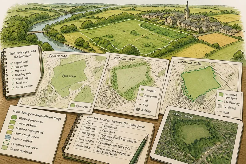
Say you are describing a green patch beside a village. The county map labels it “open space”, while a walking map marks trees only along its edge. The sensible wording is “open space with trees around the boundary”, not “forest”: each map supports the former description, while neither supports calling the whole patch a forest.
For a similar comparison, record what each source actually says before deciding on a name. An aerial image may show visible trees and clearings, but it cannot by itself explain the map’s formal categories or whether the public may enter.
Use the following checks to decide how specific your description can be:
- Legend label: If it says “woodland”, describe the mapped category as woodland; if it says only “vegetation”, use “mapped vegetation” unless another reliable source identifies it more closely.
- Map purpose: If it is a land-use or planning map, keep its designation separate from a claim about visible trees; if its purpose is unclear, check the publisher’s notes before interpreting the colour.
- Map scale: If a detailed local map shows internal features, include those distinctions; if you have only a broad county map, use a broader term such as “green space”.
- Boundary style: If the key identifies an outline as a site boundary, describe the designated area rather than treating the outline as a vegetation edge; if the key is silent, avoid assigning it either meaning.
- Second map: If two maps agree on a land-cover label, report that shared label with its source; if their categories differ, state each map’s wording rather than choosing one as universal.
- Aerial view: If it clearly shows trees at the margins and open ground inside, describe those visible features; if the image is unclear or outdated, rely on the map’s stated category and qualify the description.
- Access question: If you need to know whether entry is permitted, check the relevant local authority or land manager; if you are only naming land cover, do not infer access from the green symbol.
Choosing landscape terms
“Forest” and “woodland” refer to tree-covered landscapes, while “heath” and “grassland” describe different kinds of open ground. “Park” may refer to a managed place or a mapped designation, depending on the source. “Green space” is a useful broader term when the map combines land types or the finer detail remains uncertain.
Separate the map’s label from what you can see. For example, you might write that a county map marks a site as open space and an aerial image shows trees along its margins. That wording tells the reader which source supports each part of the description.
Questions about green shading?
Does green always mean trees?
No. A map may use green for grassland, parks, scrub, protected land or a general vegetation category. Check the legend before deciding what grows there.
Can maps give one place different labels?
Yes. Maps group land according to their purpose and level of detail. Keep each label attached to the map that defines it rather than treating one category as a universal name.
What if the map has no legend?
Look for a key in the accompanying notes or on the publisher’s map page. If you cannot find one, describe the colour or visible pattern without assigning an unconfirmed land-cover type.
Can an aerial image settle the question?
It can help you identify visible tree cover and open ground, but it may not explain formal designations, ownership or access. Use it alongside a map, not as proof of what the map’s colour means.
Use the narrowest supported name
Choose the most precise term the available evidence allows. If a map clearly labels woodland, use that category; if it gives only a broad vegetation label, say “mapped vegetation” or “green space” rather than guessing at forest, heath or grassland.
For access rights or an official designation, check the relevant local authority or land manager. A land-cover colour alone cannot answer those separate questions.
When you next describe green map shading, name the source and follow its legend label. That small distinction lets a reader tell the mapped category from the landscape features you can actually observe.