A First Look at an Unfamiliar County Map
Read an unfamiliar county map with a clear sequence: judge its scale, set its orientation, locate settlements and understand how places relate.
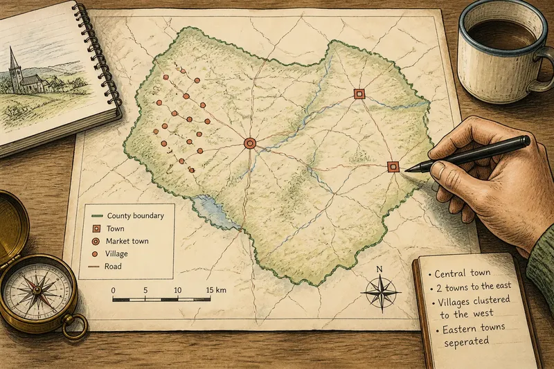
An unfamiliar county map is easier to understand when you first identify its coverage, then locate its settlements and compare how those places relate to one another. A county map is an overview, not a complete account of every lane, neighbourhood or local connection.
Begin with the title and edition, then look at the map’s scale and the way settlement labels are placed. These details help you separate what the map shows from what it leaves uncertain. You do not need to interpret every symbol to form a useful picture of the county’s settlement pattern.
Check the map’s scope
The title identifies the area covered, while the scale indicates how much ground the map represents. A county-wide sheet compresses a large area into a small space, so a settlement may appear as a dot or name rather than a detailed plan. Treat that mark as a location, not as a complete description of the place.
Check the edition date if it is shown. A general map may still help you understand where settlements sit, but it may not reflect recent development or current access. If your question depends on a present-day street layout, consult a more detailed and current map.
On a printed map, use its scale bar rather than judging distance from the page. On a digital map, note whether zooming changes the detail displayed. The same view may not retain the same level of detail after you enlarge or move it.
Decide what level of detail your question needs before drawing conclusions.
Locate the settlements
Find the named towns and villages, paying attention to the symbols beside their labels. A large name or mark may reflect the map’s design rather than a ranking of local importance. Look for the settlement symbol itself: labels are often offset to avoid covering other information.
Compare the locations. Are several villages near one another? Are there broad spaces between named places? Do towns sit in a loose line or in separate clusters? These are observations about the map. They may suggest questions about the county’s geography, but the map alone cannot establish why the pattern developed.
Some maps distinguish settlement types; others simply mark named places. If the legend does not define categories such as village or hamlet, avoid assigning those labels on the basis of symbol size alone. Place names may also refer to a wider locality, so check whether a boundary or separate mark clarifies what the name denotes.
Say you are reading an invented county map that marks one town near the centre, two towns to the east and several villages to the west. You note the named places and find that the western villages form a loose cluster, while the eastern towns are separated. The resulting description is specific—one cluster lies west of the central town—without claiming why the settlements are arranged that way.
Read settlement patterns
A settlement pattern is the visible arrangement of places across an area. It can be clustered, dispersed or aligned, but those terms describe appearance rather than cause. For example, “the villages are concentrated around the northern edge of the map” reports a pattern; explaining that pattern would require evidence beyond the map.
Check whether a map’s boundaries help make sense of the arrangement. A county outline shows the mapped area, but it does not necessarily explain how neighbouring places relate to it. A settlement just beyond the edge may be relevant to the county’s wider geography even though the map does not show its surroundings in detail.
Keep a short record of what you can see:
- If several village symbols sit close together, describe them as a cluster; if they are widely spaced, describe them as dispersed.
- If named places form a visible line, note the alignment; if they do not, avoid describing them as a corridor.
- If a town lies near the county’s centre, call it centrally placed on the map; if it lies towards an edge, describe that position instead.
- If a settlement label has no clear symbol beside it, check the legend or map notes; if neither clarifies it, leave its exact location uncertain.
- If a settlement sits close to the county outline, check whether its symbol is inside or outside; if the map is unclear, consult a map with more detail.
- If the legend names a settlement category, use that category; if it does not, refer to the place by its name without assigning one.
Each point turns a visible feature into a careful description while leaving uncertain explanations open.
Compare places and links
Once you have located the settlements, consider which places lie near one another and which are separated. A county overview may suggest that several villages are associated geographically with a nearby town, but proximity on the page does not establish how people travel or where services are used.
Look at named connections only when they help answer your question. A map may show a route passing through or between settlements, but the purpose and current condition of that route may not be clear at county scale. If your focus is the settlement pattern, you can often describe relative position without tracing every line on the map.
Try a simple comparison: choose two towns and note which villages appear nearer to each one. Then check whether the map’s scale and label placement make that comparison reliable. If the symbols are crowded or the map is too general, state the limitation rather than treating an approximate visual impression as an exact distance.
Describe relationships you can see, not relationships the map does not establish.
Questions about county maps?
Can a county map identify the largest town?
It may use different symbols or label sizes, but those features do not necessarily rank settlements by population or local importance. Check the map’s notes for an explicit measure; otherwise, describe the symbol or label rather than declaring a largest town.
How can I tell a village from a hamlet?
Use the legend if it defines those categories. If it does not, the map may not distinguish them, so refer to each place by name instead of inferring its status from the size of its label.
What should I do when a settlement label is unclear?
Look for a symbol, boundary or note that identifies the place more precisely. If the map still leaves its position or extent uncertain, check a detailed local map before making a precise claim.
Can a county map explain why settlements formed?
It can reveal patterns such as clusters, spacing and relative position, but those observations do not establish their causes. Use a local history or another suitable source if you need to investigate how a settlement developed.
Describe what you see
A clear account separates observation from interpretation. You might say that several named villages lie west of a town, while the map leaves their local boundaries unclear. That wording gives a reader useful information without implying that the map proves how the places function together.
When an important detail is missing, record the uncertainty and choose a source suited to the question. A detailed local map may clarify a settlement’s layout; a map note may explain a symbol; a relevant authoritative source may be needed for a formal boundary. The best next step depends on what the county map was designed to show.
For a first reading of an unfamiliar county map, the main search phrase is unfamiliar county map: use it to locate the area, identify the settlements and describe their visible arrangement. Keeping observations separate from explanations makes the resulting picture both useful and honest.